HTEM survey to start on March 8

Boone County residents might soon see a helicopter flying overhead with a large, circular object suspended below it. The pilot will be collecting some very important data for a team of Illinois State Geological Survey (ISGS) scientists. The information collected will transform our understanding of the local geology in a very detailed way. Our water supply is part of this local geology as water is stored and pulled from aquifers hidden from our view. We all rely on groundwater for our water supply, we have no alternative sources.
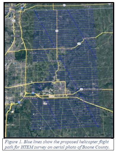
If you happen to catch a glimpse of the helicopter as it flies passes back and forth across the county collecting data for the 3-Dimensional Geologic Mapping Project, (Figure 1), you will be seeing science in action! This is a new geologic mapping technique called Helicopter-based Time-domain Electromagnetics or HTEM. SkyTEM is the aerial geophysics firm that will be conducting the aerial survey.
Even though the aerial survey will take about a week of flight time, the ISGS will have a team of scientists dedicated to converting the geophysical data into a very detailed, three dimensional, interactive, geologic maps and other digital products over the next two years. The data will be calibrated by using known points of geologic information such as cores and well logs recorded from existing drilled wells.
The results will provide an exceptional view of geologic features like shallow sand and gravel deposits that form aquifers, the precise depth of the bedrock surface, bedrock stratigraphy (layers of different sedimentary rocks) to a depth of about 1,000 feet below the ground surface. Once this detailed geology is revealed we can gain a greater understanding about our water supply and how it functions.
Our geology may seem to be fairly stable or even static. Closer observation will show that the land and water are dynamic systems. Water is constantly in motion as part of our globe’s water cycle, with many factors affecting the state of water at any given location and at any point in time.
Even though our water supply is found below our feet in aquifers hidden from view, groundwater is always moving and never static. The new 3-D geologic maps will show us some really important aspects to help us ensure we have a dependable supply of water.
We will learn where rainfall is most likely to soak in and become groundwater – a process called groundwater recharge. Local geology and soils affect whether or not precipitation can effectively enter an aquifer. Other factors can affect the natural process with people having significant influence on the landscape. Land use and land management can completely alter or enhance natural processes, including groundwater recharge.
Jessica Roberts, Boone County Planner adds her perspective on land use: “What does land use mean? Land use is just that, what is found on the land or how a property is used. For example: green fields, brown fields, agriculture, residential, commercial, industrial, preservation, conservation, are all terms used when describing land characteristics.
“Considering past, present and future uses can all affect the way water moves. Land use is guided and regulated a variety of ways as we put mechanisms in place to manage our impacts. The mechanisms used are determined by levels of government through rules and regulations. The unique aspect to the regulation of land use, what is or is not allowed, is they are made primarily at a local level.
“That means we can decide. We determine through the community’s guidance, public input, professional expertise, data and trends, what areas to develop, what areas to keep residential, and what areas to preserve. Not only do we decide that, we also get to choose how these areas develop.
“What constraints, what features, such as architecture, landscaping, impervious surface areas, and in some cases details such as materials used for development. The data and information collected by the project will be a great benefit to assist in these decisions, helping to understand what exists below the surface. Painting a more complete picture of the natural constraints, needed to make the most informed decisions.”
When this study is completed Jessica, other Boone County staff and the public will use this new information to guide future planning and important decision-making processes. Everyone will benefit from this cutting-edge science! The helicopter-based survey will begin on Saturday, March 8, following an information and media event at the Wings and Wheels Museum located at the Poplar Grove Airport. The program for this event will soon be available via a press announcement.
This is the third article in a series. You can read the previous two articles at: www.naturalland.org/geologic-study-boosts-groundwater-understanding or www.naturalland.org/understanding-our-shared-water-supply.


